The risk of a 'super' El Niño is rising. Here's what it means for North America

 Getty Images
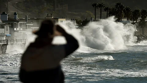
The Pacific weather event is under way and likely to intensify in the coming months. This is what it means for hurricane season, food harvests and weather across the US and Canada.
El Niño – the Pacific weather pattern that pushes up global temperatures – has started, the US National Oceanic and Atmospheric Administration (Noaa) announced on 11 June.
This natural phenomenon occurs when sea surface temperatures in the Pacific Ocean are 0.5C (0.9F) higher than normal for several consecutive months and it typically occurs every two to seven years.
Scientists forecast a 63% chance of sea surface temperatures exceeding 2C (3.6F) later this year. This would make it a "very strong" or "super" El Niño.
The disruption will be felt most in the tropics, but a strong El Niño will also lead to weather changes across North America, bringing wetter and stormier conditions to the south and drier, hotter temperatures to the north. Here's what scientists say lies ahead in the coming months.
Quieter Atlantic hurricane season
The earliest impact North America is likely to experience is a quieter-than-normal Atlantic hurricane season, between June and November.
"During an El Niño, the wind environment isn't favourable for hurricane or tropical cyclone development [in the Atlantic]," says William Baule, an atmospheric sciences researcher at Texas A&M University. The increased wind shear makes it harder for thunderstorms to form into hurricanes, he explains.
Noaa forecasters expect a below-normal hurricane season in the Atlantic this year, suggesting at most six hurricanes and 14 storms could emerge this year, with potentially three of these becoming major hurricanes and reaching Category 3 or higher. An average season has 14 storms with seven hurricanes, including three major ones.
Meanwhile, in the Pacific Ocean, hurricane activity is expected to increase as warmer waters provide more energy for storms to form. This is mainly expected to impact western Mexico, says Nat Johnson, a meteorologist in Noaa's El Niño–Southern Oscillation forecast team.
"Even though Hawaii does not see direct landfalls from hurricanes that often, the risk is enhanced during an El Niño year," Johnson adds.
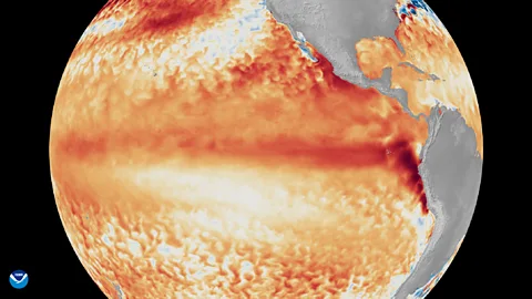 Noaa Satellites
Wetter weather in southern US
During an El Niño, the southern US starts to experience wetter conditions in autumn, says Johnson.
Increased rainfall will provide some much-needed relief to drought-stricken states in the southeastern US but "there is also an enhanced risk of flooding", says Johnson.
El Niño also causes atmospheric rivers – huge, invisible ribbons of water vapour in the sky – to make landfall more frequently. (Read more about these giant "sky rivers".)
This in turn can lead to heavier rainfall and windier conditions, "so that could be a threat, particularly over parts of the US west coast later in the winter", says Johnson.
The southern states are also likely to experience more storms, says Baule. "When El Niño is present, the jet stream is more east to west and that allows storms to pass through more quickly."
Drier and hotter in Pacific Northwest
The northern states and Pacific Northwest, meanwhile, will see hotter and drier conditions as El Niño causes the Pacific jet stream to move further south. "It tends to be warmer over the northern parts of the US and Canada and drier over the Pacific Northwest," says Johnson. "We also tend to have less snowfall over the northern Rockies."
During an El Niño, states in the Pacific Northwest are usually very warm and dry "because the jet stream is below them so they miss the storm track," says Baule.
The weather changes brought by El Niño can also spread infectious diseases by creating favourable breeding conditions for mosquitoes and other pests. During the super El Niño in 2015-2016, disease outbreaks of West Nile virus, hantavirus and the plague increased in parts of the US.
Is climate change fuelling El Niño?
Scientists are still working out the exact relationship between climate change and El Niño. Still, experts agree that the frequency of strong El Niño events is likely to increase this century due to climate change.
The World Meteorological Organization has also warned this year's El Niño "will pour fuel on the fire of a warming world", exacerbating drought, heavy rainfall and heatwaves. (Read more on why El Niño could be the strongest in decades.)
Warmer Canadian winter with less snow
In Canada, the impacts of El Niño tend to arrive around the end of the year, resulting in a milder winter, says Bill Merryfield, a climate scientist at the Canadian government's environment department.
"The warm tendency is most pronounced in the western half of Canada, but in a super El Niño, winter warmth can extend right to the eastern provinces," he says. The warm temperatures can continue into spring, especially in western Canada.
The winter and spring warmth, combined with less rainfall, particularly in the Rockies and around the Great Lakes in western Canada, can lead to less snow and drier soil, Merryfield adds. "A couple of degrees of added warmth can make a big difference and the extension of the mild temperatures into the spring can also lead to early melting of the snowpack."
An early snow melt, drier soil and below-average rainfall are also "conducive to more severe wildfires" next summer, he says.
Economic impacts
El Niño is also likely to disrupt agriculture across North America, which could impact supply chains and food prices.
"There is some concern for agriculture going into summer and into the fall [autumn], that if the Midwestern states see less than normal precipitation, this could impact crop production in the breadbasket," says Baule. Meanwhile, flooding in the southern US could impact wheat and cotton production, he adds.
More like this:
But more rainfall could also lead to increased winter wheat yields in the Southern Great Plains, says Weston Anderson, an assistant research professor at the University of Maryland in the US who studies how El Niño events impact crop yields.
The world recently emerged from its cooler counterpart, La Niña, which has "led to frequently poor years and greater crop failures in the drier portions of the Southern Great Plains," says Anderson. "So I hope this El Niño will bring some much-needed relief to the area."
Johnson says this El Niño "could be among the strongest we've seen over the past century". The last event of this kind occurred in 2015-2016 and resulted in a new global temperature record and a once in 500-year drought in the Caribbean.
Scientists will keep tracking how this El Niño unfolds, but however it plays out, it appears likely impacts will significantly affect many people's lives.
--
For essential climate news and hopeful developments to your inbox, sign up to the Future Earth newsletter, while The Essential List delivers a handpicked selection of features and insights twice a week.
