Quick version
Upland limestone landscapes occur in a variety of places over the British Isles:
- Yorkshire Dales
- North Yorkshire Moors
- Peak District
- Brecon Beacons
Due to limestone being A type of rock which allows water to pass through its joints and cracks, eg limestone. and the processes of physical and The erosion of rocks by chemicals that react with their minerals. , it is eroded into a variety of distinctive surface features:
- A surface made up of flat slabs of limestone.
- potholes/swallow holes
- intermittent drainage
Location of upland limestone landscapes
The map below shows where the A type of sedimentary rock found in mountainous areas. landscapes are located over the British Isles.
Examples of upland limestone landscapes in the British Isles
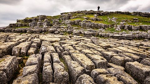
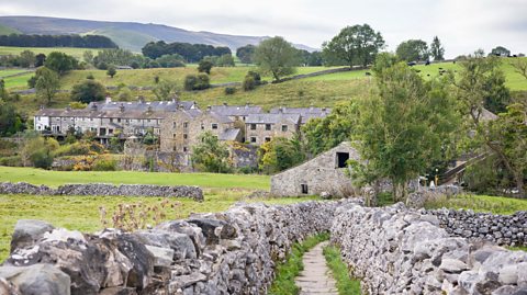
Image caption, Yorkshire Dales, England
The Yorkshire Dales National Park is famous for its limestone features, like the limestone pavements at Malham Cove. (travellinglight / Alamy Stock Photo)


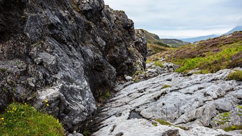
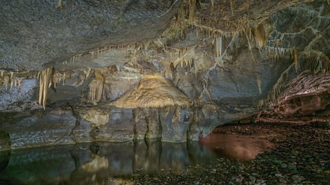

1 of 7
Surface features of limestone landscapes
Video
In this video, learn how different surface features are formed in limestone landscapes.
The formation of clints, grykes and swallow holes in limestone landscapes.
Upland limestone landscapes have many distinctive features, like with this limestone pavement during periods of glaciation, soil has been scraped away to expose the rock beneath.
As limestone is permeable, water flows down through cracks and into the rock. Over time, chemical weathering dissolved the rock and widened these cracks into grykes.
The blocks between are called clints. When river and streams reach limestone, the water disappears down joints and cracks, the volume of water causes much more erosion. It widens joints to form swallow holes or potholes.
These can be many metres deep. This water continues to flow underground until it reaches impermeable rock and resurfaces on the landscape. This is called intermittent drainage.
Limestone pavements, swallow holes and intermittent drainage: key surface features of this upland landscape.
Limestone pavements
- During periods of The build up of ice on the land during colder periods in time., A type of glacial erosion that occurs when rock fragments that are frozen into the bottom of a glacier scape and erode the valley floor. scraped away the topsoil to expose the bare rock underneath.
- As limestone is a A type of rock which allows water to pass through its joints and cracks, eg limestone., water is able to seep down through the cracks and into the rock.
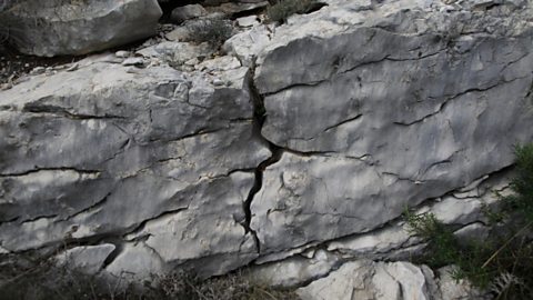
- Rainwater is a weak carbonic acid which reacts with the limestone as it passes through the rock, dissolving the stone while enlarging A crack in a rock formed when the rock dried out or pressure is released. and .
- On the surface the chemical weathering widens and deepens cracks to form grykes.
- This leaves exposed blocks of limestone called clints and the resulting pattern of blocky rock is called a limestone pavement.
Potholes/swallow holes
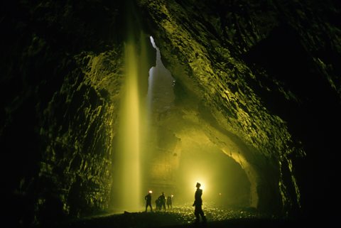
- Surface water and rain do not flow far on exposed limestone as they rapidly infiltrate into the rock and soil.
- Where a joint or intersection of joints has been greatly weathered or dissolved, water can pass down through the limestone.
- A stream travelling over an impermeable rock will very quickly disappear when it has to travel over limestone.
- These swallow holes can be many metres deep leading down to a series of underground features.
- An example of a swallow hole in the Yorkshire Dales is Gaping Gill.
Swallow holes
In this video, learn how swallow holes, like Gaping Gill, and other upland limestone drainage features are formed in limestone landscapes.
Explore upland limestone drainage features
Because limestone is permeable, surface water goes to ground.
Streams which have their source on impermeable rock on higher land travel overground across the top of the impermeable rock until they reach limestone.
When it reaches the limestone, the water will find its way down a joint through the rock and travel underground. The name of this feature is a swallow hole. A famous example of a swallow hole is found on Ingleborough. At the poiht, Fell Beck reaches the limestone it has dissolved the rock at a weak joint and continued its journey underground.
At this swallow hole, known as Gaping Gill, the water has dissolved a wide hole. The water from the Beck pours down a one hundred and ten metre shaft into a huge chamber, creating a magnificent underground waterfall: the highest waterfall in Britain.
Then the water continues to flow underground and reemerges one point seven five kilometres south at Ingleborough Cave where the limestone meets the impermeable rock beneath it at the valley floor.
Next to the cave entrance there is a resurgence where water reemerges. The water flows on down the dale towards the village of Clapham.
On Ingleborough, we can see many areas where land has subsided in the hollows around widened joints in the limestone. This feature is known as a shake hole. It happens after boulder clay is washed away by water.
Streams also disappear underground at a feature called a water sink. A good example of a water sink can be seen near Malham. Malham Tarn is a natural upland lake, the lake sits on a bed of shale and impermeable rock lying above the permeable limestone. The water from the tarn flows south, downhill.
Approximately five hundred metres from the shore of the tarn, it reaches the edge of the impermeable rock and flows onto the limestone. Here, the water sinks into the ground. This stream travels through an underground system and then reemerges three point five kilometres south at the valley floor, when it reaches new impermeable rock.
At the foot of Malham Cove, there is a resurgent stream. There is also another resurgence two kilometres further south here at Aire Head. All around this area on the valley floor where the limestone ends and meets impermeable rock you find resurgent streams.
Intermittent drainage
- When a stream disappears through the permeable limestone, it travels underground through a complex series of caves.
- It eventually works its way down to a level of impermeable rock or until it reaches the top of the water table.
- The stream flows over the impermeable rock until it reaches the surface as a spring.
- Where limestone lies on top of impermeable rock along a valley there can be several springs formed along the intersection of the two rocks. This is called a spring line.
- An example of a disappearing/reappearing stream in the Yorkshire Dales is Fell Beck.

Scars and scree
Scar
Scars are exposed cliffs of limestone. They were created during the last ice age, when huge sheets of ice scraped away the soil-covered spurs in many valleys in the Yorkshire Dales.
The exposed surface is affected by freeze-thaw action on the well-jointed limestone. Water enters the cracks and if it freezes, expands. As the water expands, so do the cracks.
A dramatic example of scar landscape can be found at Twistleton Scar in the Yorkshire Dales.
Scree
Repeated freezing and thawing eventually breaks off rock and at the bottom of the scar cliff a talus or scree slope is formed. The Wastwater Screes in the Lake District are a famous example.
Gorge
A cavern formed underground in a limestone landscape expands. The ceiling of the cavern becomes unsupported and collapses. This leaves a steep sided valley called a gorge.
Sample question
Identify the features marked on the diagram by matching them to the names of features given.
Quiz
Recap
Upland limestone landscapes occur in a variety of places over the British Isles.
Due to limestone being A type of rock which allows water to pass through its joints and cracks, eg limestone. and the processes of physical and The erosion of rocks by chemicals that react with their minerals. , it is eroded into a variety of distinctive features:
- A surface made up of flat slabs of limestone.
- potholes/swallow holes
- intermittent drainage
More on Upland limestone landscapes
Find out more by working through a topic
- count1 of 5