13 November 2014 |

| |
BBC Homepage | |||
Contact Us | |||
General FeaturesYou are in: Wear > Features > General Features > Down by the river 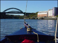 Sailing up the Wear Down by the riverHow far can you sail up the River Wear in a 1930s fishing boat with a 1960s map? BBC Radio Newcastle’s Martin Emmerson went to find out. A chilly winter’s morning is not the best of times to set sail up the River Wear in an open boat, particularly when there’s no shelter from the elements. However on this occasion we had a job to do and the tide was high.
Our captain was my neighbour Peter Mitchell, a former sailor and lecturer in navigation. His map for the day was a 1960s Ordnance Survey map of Wearside which would allow us to chart the changes around the Sunderland area in the last 40 years. Our boat was the Paramatta – an old Orkneys fishing boat from the 1930s which Peter and his friend Gerry McGill restored at Gerry’s workshops on the banks of the River Wear. In the 70s the boat was used to teach sailing to pupils from Redhouse School in Sunderland. Back then, if there was no wind they had to row. I was thankful for the small engine we had. DisrepairThe boat had fallen into a state of disrepair when Peter and Gerry got their hands on it. A similar boat sits on the side of the marina at Sunderland filled with flowers. At least the Paramatta didn’t come to such an end! The name, in case you are wondering, comes from Sydney where the River Paramatta flows. So just after 10.30am, we headed off from the marina on the back of one of the highest tides of the winter. We were counting in bridges, not distance. We needed to reach at least eight bridges to equal the voyage made by Gerry and his crew the previous day. Although it was chilly, the sun was out and we were wrapped up against the elements. My wife Julia made up the crew and supplied the soup too on this particular Sunday morning! Bridges one and two were easy. The Wear Bridge into Sunderland City Centre and the adjacent railway bridge were reached within a matter of minutes. Then we sailed around the back of the Stadium of Light, past the old coal staithes and on towards the Queen Alexandra Bridge. ExpensiveWe took the corner, past the Liebherr Crane depot, very wide to avoid the mud banks. The river is silting up quite badly now because it hardly gets dredged these days. It’s too expensive.  The Victoria Viaduct near Fatfield Our 1960s map showed a hive of activity in this region, not least the massive Wearmouth Colliery where the stadium now stands. As we turned towards the Queen Alexandra Bridge we saw the first glimpses of what the refurbished bridge will look like when the work on it finishes. It is now dark green with red lines. The colour reminded me of a canal boat or an Eddie Stobart lorry. We pushed on past one of the large sheds housing a Sea Cat ferry which is in there for repair and past the dilapidated former Isle of Man ferry which has been listing on the river for years. The cold was by now biting against the flesh and we were still powering along on the engine because the wind was either wrong or not strong enough. By now I was craving the shelter of the gorge near the A19 at Hylton. Small plotOn the south side of the river, the map marked a small plot known as Pennywell Spring. In the 60s there wasn’t much there. It became the site of one of the city’s biggest council estates. Town End Farm was just that – a farm. Wessington Way, the main road out of Sunderland on the north side of the river was nothing more than a collection of railway lines and colliery land. Eventually we reached the comparative shelter of the bridge at the A19 (number three on our list) with the Shipwright’s Arm on the North bank and the Golden Lion on the South. Then the River Wear changed it’s nature as we headed into the gorge on the west side of the A19. It became calm, countrified and narrower. On we cruised past the Washington Wildfowl Park (a lot bigger than I remember it as a kid) and then to our first major obstacle. With the tide high we could not get under the foot bridge at Cox Green because of the mast. I slowed the engine as we approached the Alice Villas and the bridge. The Oddfellows Arms looked quite appealing on the south bank of the river but we needed to press on.  Skipper Peter Mitchell prepares the boat Peter and Julia set about unrigging the mast while I tentatively moved us towards the bridge. We got under – just! I doubt there was more than an inch to spare with the mast lying at a low angle. If the tide had come in any more we would not have been able to get back under there on the way home. Victoria ViaductWe were sailing in a southerly direction by now. As we rounded the next bend we saw the Victoria Viaduct for the first time (bridge five). The sun blazed through its arches. It used to carry local rail and mineral lines but has not been used in decades. Back in the days before Beeching’s Axe you could have travelled across the viaduct on a local train and gone onto places like Penshaw, Shiney Row and Chester-le-Street. By now we were mixing with a number of jet skiers and a speed boat pulling a wake border. I know where “wake board” bit comes from. They were moving at such a speed the wake they left nearly sent us overboard! The road bridge at Fatfield came next and then we passed under the Washington Highway and into a new world. We’d made it to our eighth bridge and with the tide still right and the daylight allowing us a few more minutes of cruising time we pressed on. The river was full of life. There were more ducks than I’ve seen anywhere before. There were geese and swans in abundance. Along the banks there were pheasants and rabbits. We realised from the map we were cruising through the vast Lambton Estate on the edge of Rickleton Wood. The next bridge on the map was called New Bridge and we were nearing a new record for the Paramatta. UnstuckSadly the river left its Southerly path and took a sharp turn to the right and it was here, heading North West again, that we came unstuck. There was a small island which made the river a lot narrower. Not knowing what was around the corner, we slowed up. The skipper took the decision to turn the boat around and that’s when we ran into trouble. The mast got snagged in the trees hanging above and our adventure was over. We were just yards from bridge number nine but we had ground to a halt. For a while it seemed we would be stuck there for a long time. By now the sun was starting to go down and we had less than two hours to navigate back down to the mouth of the river. It took a while but we managed to get free. Bridge nine was not to be on this occasion, which was a pity, because once we sailed back to Sunderland marina, the boat was lifted out of the river for the remainder of the winter. The record would have stood for months, possibly years. However, next summer when the Paramatta is back in the water, Peter and Gerry will resume their battle and no doubt I’ll find myself at the tiller again. last updated: 29/10/2008 at 09:57 SEE ALSOYou are in: Wear > Features > General Features > Down by the river |
About the BBC | Help | Terms of Use | Privacy & Cookies Policy |
